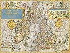
Speed, John. Britain's Tudor Maps County by County. Introduction by Nigel Nicolson. County Commentaries by Alasdair Hawkyard. London: Batsford, published in association with the British Library, 2016.
I love maps! This gorgeously illustrated book of county maps produced by John Speed in the Tudor period provides today's researchers a great tool for understanding our British ancestors who lived then. Each county map is accompanied by a commentary written by Alasair Hawkyard, providing insight into the county's history and the people who resided there. Many maps include offset maps depicting specific places, much as modern-day atlases include maps of larger cities. It's a large over-sized "coffee table" book, but it is so full of useful content for genealogists and historians dealing with the period and place.
No comments:
Post a Comment